Can GPS mapping show live traffic updates? If you’ve ever found yourself stuck in a traffic jam, you know the frustration of being late to your destination. But what if there was a way to avoid those traffic snarls and reach your destination on time?
Well, GPS mapping might just be the solution you’re looking for! With GPS technology and real-time data, you can get live traffic updates that help you navigate around congested areas and choose the fastest route. So, let’s dive in and explore how GPS mapping can make your journey smoother and more efficient.
But how does GPS mapping capture live traffic updates? Well, it’s all thanks to a combination of GPS satellites, mobile data, and user contributions. GPS satellites orbiting the Earth constantly transmit signals, allowing your GPS device to determine your precise location.
By connecting to the internet, your GPS system can access and display traffic information gathered from other users who are on the road. This crowd-sourced data includes details about accidents, road closures, and even the average speed of vehicles on different routes. With this wealth of information, GPS mapping can guide you through the quickest and most efficient paths.
So, the next time you’re planning a road trip or navigating your daily commute, consider harnessing the power of GPS mapping to get live traffic updates. With its real-time data, alternative routes, and estimated travel times, you’ll have the tools to avoid traffic congestion and reach your destination hassle-free.
Get ready to say goodbye to traffic woes and hello to smoother, stress-free journeys with GPS mapping’s live traffic updates. Let’s hit the road!
Can GPS Mapping Show Live Traffic Updates?
GPS mapping can provide real-time traffic updates, allowing users to stay informed and make smarter decisions on the road. By integrating live traffic data, GPS mapping systems can show current traffic conditions, including congestion, accidents, and construction zones.
This feature enables drivers to plan their routes accordingly and avoid delays. Stay connected to the latest traffic information with GPS mapping and arrive at your destination faster and more efficiently.
Role of GPS in Live Traffic Updates
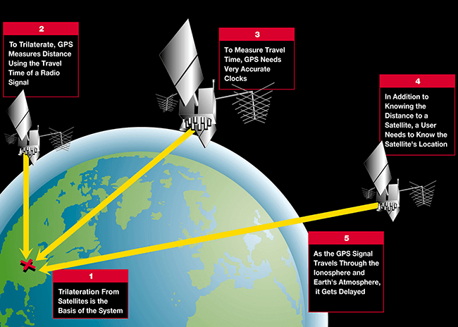
GPS, or Global Positioning System, is a technology that uses satellites to determine the precise location of an object or person. GPS mapping systems, commonly found in navigation devices or smartphone applications, utilize this technology to provide users with accurate directions from one point to another.
However, GPS can do much more than just calculate routes. It can also gather data from various sources, including traffic monitoring systems, to offer real-time updates on traffic conditions.
When it comes to live traffic updates, GPS mapping systems rely on a combination of methods to gather and present information. One common approach is using traffic broadcasting systems, such as radio signals or cellular networks, to receive data about traffic congestion, accidents, or road closures.
This data is then integrated into the GPS mapping software, allowing users to see the current state of roads and highways on their devices.
Additionally, some GPS mapping systems also take advantage of crowd-sourcing, where drivers share their real-time experiences on the road, helping to create a more comprehensive and accurate picture of traffic conditions.
How GPS Mapping Systems Show Live Traffic Updates
GPS mapping systems use various techniques to display live traffic updates to users. These updates can include information about traffic congestion, accidents, road closures, construction zones, and even speed limits.
Let’s explore some of the common methods used:
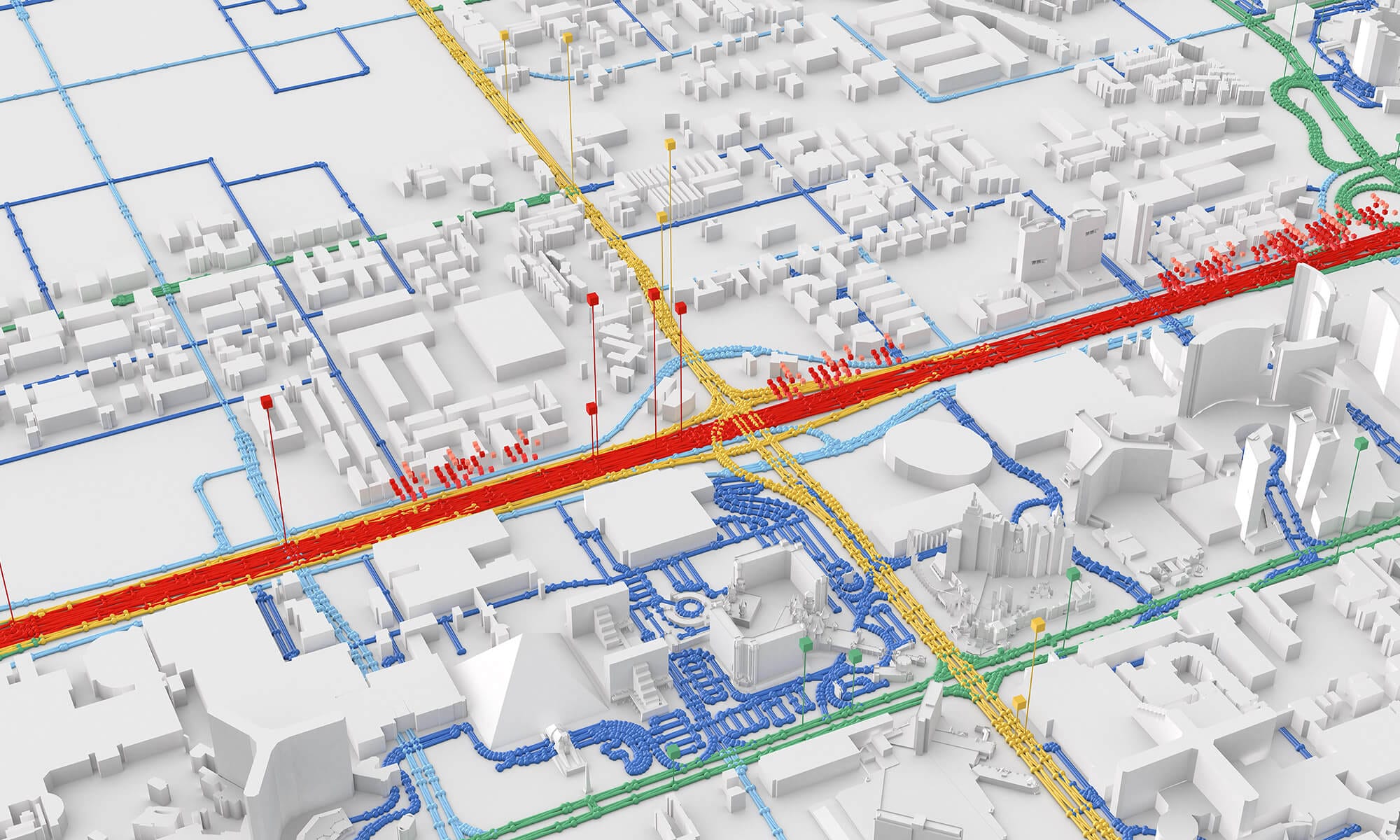
Color-Coded Traffic Overlay:
The most popular way to show live traffic updates on GPS mapping systems is through color-coded overlays. With this method, different colors represent different levels of traffic congestion. For example, green indicates free-flowing traffic, yellow represents moderate congestion, and red indicates heavy traffic.
By looking at the color-coded overlay on the map, users can quickly identify areas with heavy congestion and make informed decisions about alternative routes.
Traffic Flow Indicators:
Another way GPS mapping systems display live traffic updates is by utilizing traffic flow indicators. These indicators can provide users with real-time information about the speed of traffic on particular roads or highways.
For example, an arrow pointing upwards indicates that the traffic is flowing smoothly, while a downward-facing arrow suggests that the traffic is slow or at a standstill. By combining this information with the color-coded overlay, users can get a comprehensive understanding of the current traffic situation.
Dynamic Route Guidance:
One of the key advantages of GPS mapping systems with live traffic updates is the ability to dynamically reroute users based on the current traffic conditions. When there is a significant traffic jam or congestion ahead, the GPS mapping system can automatically calculate an alternative route to avoid the affected area. This feature helps drivers save time and navigate through traffic more efficiently.
In summary, GPS mapping systems can indeed show live traffic updates by utilizing various techniques such as color-coded overlays, traffic flow indicators, and dynamic route guidance.
These features empower drivers with real-time information about traffic conditions, allowing them to make informed decisions and enhance their driving experience.
Whether you’re commuting to work or embarking on a road trip, having access to live traffic updates through GPS mapping can significantly improve your journey.
Frequently Asked Questions
Curious about whether GPS mapping can provide live traffic updates? Look no further. Below are some common questions and their answers to help you understand how GPS mapping handles live traffic updates seamlessly.
Can GPS mapping display real-time traffic information?
Absolutely! GPS mapping systems nowadays are equipped with real-time traffic data that can be displayed on your device. These systems collect traffic information from various sources, such as traffic sensors, road cameras, and mobile device signals.
The GPS then processes and analyzes this data to show you live traffic updates on your map. These updates include information about congestion, accidents, roadwork, and other factors that may affect your route.
By using GPS mapping with real-time traffic updates, you can make informed decisions about your travel route, avoiding traffic jams and finding the quickest way to your destination. It takes the guesswork out of navigating through busy streets and helps you get to your destination efficiently.
How accurate are live traffic updates on GPS mapping?
Live traffic updates on GPS mapping are generally quite accurate. The data is gathered from multiple sources and continuously updated to reflect the current traffic conditions. However, it’s important to keep in mind that accuracy can vary depending on the quality and reliability of the data sources.
Additionally, unforeseen circumstances like sudden accidents or road closures may cause temporary inaccuracies in the live traffic updates.
Despite these rare instances, GPS mapping with live traffic updates still provides valuable information to help you navigate through traffic. It’s always a good idea to cross-reference the live traffic updates with other sources, such as local news or radio traffic reports, to get a more comprehensive understanding of the current traffic situation before making any decisions.
Can GPS mapping reroute based on live traffic updates?
Yes, GPS mapping can reroute your journey based on live traffic updates. When you encounter heavy traffic or a road closure, the GPS system will automatically analyze the live traffic data and calculate alternative routes that are more efficient and less congested.
It will then guide you with turn-by-turn directions to help you avoid the traffic and reach your destination faster.
Rerouting based on live traffic updates is particularly helpful for long trips or commutes, where unexpected delays can significantly impact your journey. By relying on GPS mapping to reroute, you can save time, reduce stress, and hopefully arrive at your destination on time.
Which GPS mapping apps provide live traffic updates?
Several popular GPS mapping apps offer live traffic updates as a standard feature. Google Maps, Waze, and Apple Maps are some of the most widely used apps that provide real-time traffic information. These apps utilize data from various sources and take advantage of user-generated information to provide accurate and up-to-date traffic updates.
When using a GPS mapping app, make sure you have a stable internet connection for the best experience with live traffic updates. It’s also important to keep the app updated to benefit from the latest improvements and enhancements in traffic data accuracy.
Can GPS mapping show live traffic updates in rural areas?
GPS mapping systems typically prioritize live traffic updates in urban and suburban areas where traffic congestion is more common. Therefore, live traffic updates in rural areas may be limited or not as detailed as in more densely populated regions. However, some mapping apps still provide basic coverage of live traffic information, even in rural areas.
If you’re traveling through rural areas, it’s recommended to plan your route in advance and have an idea of the general driving conditions in those areas. While live traffic data may be limited, GPS mapping can still guide you accurately and help you find the fastest route to your destination.
GPS mapping can help us get real-time traffic updates and choose the best routes. It uses satellites to track vehicles and analyze traffic patterns. By using this technology, we can avoid traffic jams and save time on our journeys.
However, it is important to remember that GPS maps may not always be 100% accurate, so it’s a good idea to double-check with local traffic reports.
In addition to live traffic updates, GPS mapping also offers other benefits like finding nearby gas stations and restaurants. It is a convenient tool that can make our travels easier and more enjoyable.
So, next time you’re heading out on a road trip, don’t forget to use GPS mapping for a smoother and stress-free journey.