Do you ever wonder how your GPS knows exactly where you are and how to get you to your destination? It all comes down to satellites. But have you ever thought about how many satellites are actually needed to ensure accurate navigation? In this article, we’ll explore the fascinating world of satellite navigation and answer the question, “How many satellites are required for accurate navigation?” So, buckle up and get ready to embark on an exciting journey through the skies!
Satellites play a crucial role in helping us navigate our way through this vast world. They act as reference points in space, beaming down signals that our GPS devices pick up. But how many satellites are necessary to ensure accurate and reliable navigation? The answer may surprise you. In fact, it’s not just about the number of satellites but also their arrangement and coverage. So, let’s dive deeper into this topic and uncover the secrets behind accurate navigation.
Whether you’re driving to a new city or exploring nature’s wonders, having accurate navigation is essential. Thanks to a network of satellites orbiting high above the Earth, our GPS devices can pinpoint our exact location and guide us to our desired destination. But how many satellites are needed to achieve this level of accuracy? Stick around as we unravel the mysteries of satellite navigation and discover the optimal number of satellites required for ensuring accurate navigation. Let’s get started!

How Many Satellites Are Required For Accurate Navigation?
Navigation has become an integral part of our daily lives, whether it’s driving to a new location or finding our way through a bustling city. But have you ever wondered how accurate navigation systems, such as GPS, work? This article will delve into the fascinating world of satellite-based navigation and explore the number of satellites required for accurate positioning.
How Does Satellite-Based Navigation Work?
In order to understand the number of satellites required for accurate navigation, it is essential to grasp the foundational principles of satellite-based navigation systems. The Global Positioning System (GPS) is the most widely used satellite navigation system, developed and operated by the United States government. The GPS comprises a constellation of satellites orbiting the Earth, transmitting signals that are received and interpreted by GPS devices or smartphones.
Each GPS satellite continuously broadcasts its location and time information. By receiving signals from multiple satellites, GPS devices can triangulate the user’s position accurately. The distance between the receiver and each satellite is calculated based on the time it takes for the signals to reach the receiver. By intersecting these distances, the device determines the user’s exact location on Earth, often with impressive accuracy.
The Role of Satellites in Navigation
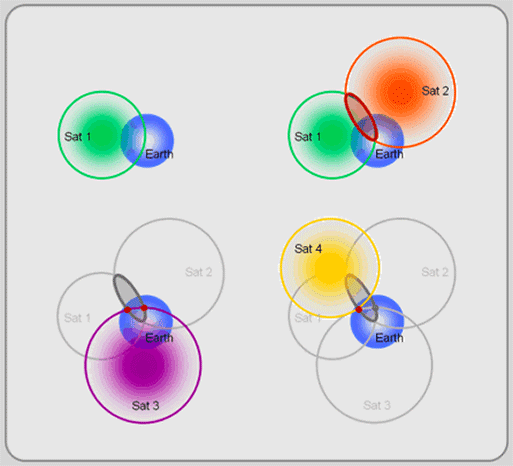
The number of satellites plays a crucial role in the accuracy of navigation systems. While it is technically possible to determine a position with only one satellite, the accuracy would be significantly compromised. With a single satellite, the receiver can only provide the user’s latitude and longitude with an accuracy of several hundred meters. This level of imprecision renders it impractical for most navigation applications.
As the number of satellites increases, so does the accuracy of positioning. With two satellites, the user can determine their position within a circular area where the two satellite signals intersect. Although better than a single satellite, this method still does not yield a highly precise location. However, as the number of satellites increases, the intersection becomes more defined, allowing for more accurate positioning.
Ideally, a GPS device needs signals from at least four satellites to provide accurate three-dimensional positioning: latitude, longitude, and altitude. By receiving signals from four or more satellites, the device can account for errors caused by variables such as atmospheric conditions and signal delays. These additional signals allow for a more precise calculation, resulting in accurate positioning within a few meters.
The Magic Number: Four Satellites for Accuracy
While four satellites are the minimum requirement for accurate positioning, many navigation systems and devices receive signals from more satellites. By receiving signals from a larger number of satellites, the system can further enhance accuracy by increasing redundancy and improving signal reliability.
Navigation systems designed for precise applications, such as aviation or maritime navigation, often utilize more than the minimum required number of satellites. By employing a larger constellation of satellites, these systems can mitigate issues caused by signal interference, multipath reflections, or signal blockage due to structures or terrain.
In conclusion, at least four satellites are required for accurate navigation. However, navigational systems often incorporate additional satellites to improve accuracy, reliability, and signal availability. Whether we’re using GPS for driving, hiking, or exploring new places, we can rely on these sophisticated satellite systems to provide us with accurate and reliable positioning information.
Factors Affecting Navigation Accuracy
While the number of satellites plays a significant role in navigation accuracy, several other factors also impact the overall precision of satellite-based positioning systems. Here are some key factors that can affect the accuracy of navigation:
Signal Strength and Quality
Strong and clear signals from satellites are essential for accurate positioning. Obstructions such as tall buildings, mountains, or dense vegetation can weaken or block signals, leading to degraded accuracy. Similarly, interference from other electronic devices or radio signals can disrupt the GPS receiver’s ability to accurately calculate positioning information.
Atmospheric Conditions
The atmosphere can introduce errors in GPS positioning due to factors such as ionospheric delay and tropospheric refraction. Ionospheric delay occurs when GPS signals pass through the charged particles in the upper atmosphere, causing minute timing discrepancies. Tropospheric refraction refers to the bending of GPS signals as they pass through the lower atmosphere, potentially altering the path and arrival time of the signals.
Receiver Quality and Algorithms
The quality and capabilities of the GPS receiver can significantly impact navigation accuracy. Higher-quality receivers often incorporate sophisticated algorithms that can correct for some of the errors and discrepancies caused by factors like signal interference, multipath reflections, or atmospheric conditions. It is crucial to invest in a reliable GPS receiver to ensure optimal accuracy.
Geographical Location
The geographical location on Earth can affect navigation accuracy to some extent. In certain regions, such as urban areas with tall buildings or dense forests, the presence of obstructions can impact signal reception, leading to reduced accuracy. Additionally, the position of the satellites in the sky relative to the user’s location can also affect the signal strength and geometry, influencing the accuracy of positioning.
Time and Satellite Orbits
The time at which GPS positioning is performed can impact accuracy due to the position of the satellites in their orbits. The geometry of the satellite constellation changes over time, which means that the accuracy of navigation can vary depending on the specific time of measurement. It is important to consider this variability when using GPS for critical applications requiring high precision.
Environmental Conditions
Environmental conditions, such as extreme weather events, can also impact satellite-based navigation systems. Heavy rain, thick fog, or severe storms can interfere with the reception of GPS signals, potentially reducing accuracy. Keeping abreast of current weather conditions and potential disruptions is important for maintaining reliable navigation.
Choosing the Right Navigation System
With numerous satellite navigation systems available today, it can be challenging to determine which one is best suited for specific needs. Here are some factors to consider when choosing a navigation system:
Purpose of Navigation
Consider the specific purpose for which the navigation system will be used. Different systems cater to various applications, such as driving, hiking, maritime navigation, or aviation. Assess the features and capabilities of each system to ensure it aligns with the intended purpose.
Accuracy Requirements
Determine the required level of accuracy for the intended application. If high precision is crucial, such as in professional surveying or scientific applications, it may be necessary to invest in more advanced systems that offer centimeter-level accuracy. For general navigation purposes, however, systems with meter-level accuracy may suffice.
Signal Reception and Availability
Consider the environments in which the navigation system will be used. If you anticipate using the system in heavily obstructed areas, such as dense forests or urban canyons, it is important to choose a system with strong signal reception capabilities and a large number of satellites in the constellation.
User-Friendliness and Interface
The user interface and overall user-friendliness of the navigation system should not be overlooked. Ensure that the interface is intuitive and easy to navigate, allowing for seamless operation in any situation. Look for features such as clear and legible displays, easy-to-understand menus, and intuitive controls.
Additional Features and Connectivity
Consider any additional features or connectivity options that may enhance the overall user experience. This could include features such as real-time traffic updates, voice-guided directions, offline maps, or Bluetooth connectivity to external devices. Assess whether these additional features align with your needs and preferences.
Budget
Finally, consider the budgetary constraints when choosing a navigation system. Prices can vary significantly depending on the features, capabilities, and brand. Determine the maximum budget and weigh the available options to find the system that offers the best value for money.
By considering these factors, users can select a navigation system that meets their specific needs, ensuring accuracy, reliability, and an enhanced overall navigation experience.
Key Takeaways: How Many Satellites Are Required For Accurate Navigation?
- At least four satellites are required for accurate navigation using the Global Positioning System (GPS).
- These satellites work together to provide precise location and timing information.
- Having more satellites in view increases the accuracy of navigation.
- Satellite signals can be affected by various factors, such as buildings, trees, and weather conditions.
- When multiple satellites are available, the GPS receiver can calculate the user’s position with greater accuracy.
Frequently Asked Questions
Navigation systems rely on a network of satellites to provide accurate positioning information. The number of satellites required for accurate navigation depends on several factors. In this section, we’ll answer some common questions related to how many satellites are needed for accurate navigation.
1. How do satellites help with navigation?
Satellites play a crucial role in navigation by providing positioning signals to receivers on the ground. These satellites constantly transmit signals that contain information about their location and the precise time of transmission. By receiving signals from multiple satellites, a navigation device can calculate its own position accurately.
The more satellites a device can “see,” the more accurate the navigation can be. This is because each satellite provides a signal that helps determine the receiver’s distance from that satellite. By triangulating these distances, the receiver can calculate its precise location.
2. How many satellites are typically used for navigation?
In most global navigation systems, such as GPS (Global Positioning System), a minimum of four satellites is required for accurate positioning. However, having more satellites in view can improve the accuracy even further.
With only three satellites, a receiver can determine its latitude and longitude but not its altitude. The fourth satellite provides the necessary information for altitude calculation. Additional satellites can help improve the accuracy by providing more precise positioning data.
3. What happens if there are fewer than four satellites available?
If there are fewer than four satellites available, it becomes more challenging for a navigation device to accurately calculate its position. In such cases, the accuracy may decrease, and the device may experience difficulties in determining the exact location.
If, for example, only two satellites are visible, the receiver can only determine its position as a point on a circle intersecting those two satellites. With three satellites, the receiver can narrow down its position to two possible points on the Earth’s surface where the circles intersect. The fourth satellite is needed to resolve this ambiguity accurately.
4. Can the accuracy of navigation be improved with more satellites?
While having four satellites is the minimum required for accurate navigation, having more satellites in view can improve the accuracy even further. When more satellites are available, the receiver has a wider range of signal sources to work with, allowing for better accuracy and precision.
Additionally, more satellites can help overcome obstacles that may block signals from certain satellites. If a receiver has a clear view of multiple satellites at any given time, it can better calculate its position and mitigate factors such as buildings or dense tree cover that may obstruct signals from specific satellites.
5. Are all navigation systems reliant on satellites?
While most widely-used navigation systems, such as GPS, GLONASS, and Galileo, rely on satellite networks, other navigation methods also exist. Some navigation systems use ground-based beacons or signals from cell towers to aid in positioning. However, these alternative methods may not offer the same level of accuracy as satellite-based systems.
Satellite-based navigation systems, with their global coverage and highly precise positioning capabilities, have become the standard for accurate navigation in various industries and everyday applications.
Summary
Having accurate navigation is important, and satellites play a crucial role in achieving it. A minimum of three satellites is needed for accurate positioning, but having access to more satellites increases accuracy. Signals from satellites help determine our location, speed, and direction of movement.
However, factors like tall buildings, heavy tree cover, and bad weather can affect satellite signals, making navigation less accurate. GPS systems work by calculating the time it takes for signals to reach us from different satellites, and more satellites improve the accuracy of this calculation. So, the more satellites available for navigation, the better!