Have you ever wondered how GPS data is collected and processed for mapping? Well, get ready to dive into the fascinating world of GPS technology as we uncover the secrets behind this incredible mapping tool!
In this article, we’ll explore the ins and outs of how GPS data is gathered and transformed into accurate and detailed maps. From the satellites hovering above us to the devices in our hands, we’ll unravel the process step by step.
So, get comfortable and join us on this journey to discover the inner workings of GPS data collection and processing for mapping. Let’s dive in and uncover the hidden marvels of GPS technology!

How is GPS Data Collected and Processed for Mapping?
GPS data collection for mapping involves several steps. First, satellites transmit signals received by GPS receivers. These receivers determine the exact location and timestamp.
Next, the collected data is processed, including filtering out errors and calculating precise positions. This processed data is then used to create accurate maps. Through this systematic process, GPS technology ensures reliable mapping for various applications.
GPS Data Collection Methods
When it comes to collecting GPS data for mapping, there are different methods employed depending on the specific requirements of the project. Here are some commonly used GPS data collection methods:
1. Real-Time Kinematic (RTK) Surveying
RTK surveying involves the use of GPS receivers, base stations, and radios or cellular networks to collect high-accuracy GPS data in real time.
The base station broadcasts correction signals to the GPS receivers, enabling them to determine their precise position. This method is commonly used for surveying large areas or when high accuracy is required.
In the field, surveyors carry a GPS rover that receives the correction signals from the base station. As they move, the GPS rover continuously adjusts its position based on the received correction signals, resulting in accurate and real-time GPS data. This data can then be processed to create detailed maps.
2. Mobile Mapping Systems
Mobile mapping systems combine GPS technology with additional sensors, such as LiDAR (Light Detection and Ranging) or cameras, mounted on vehicles or drones. These systems collect data while the vehicle or drone is in motion, covering large areas quickly and efficiently.
As the vehicle or drone moves, the integrated sensors capture GPS coordinates along with other data points, such as distance measurements or images. This data is then synchronized and processed to create detailed maps, including 3D models and point cloud data.
3. Crowd-Sourced GPS Data
In recent years, the widespread use of smartphones and GPS-enabled devices has led to the emergence of crowd-sourced GPS data collection. Apps and platforms like Google Maps or Waze utilize the GPS capabilities of users’ devices to collect and aggregate real-time GPS data.
Users voluntarily share their location and movement data, which is then anonymized and aggregated on a large scale. This crowd-sourced data provides valuable insights into traffic patterns, road conditions, and other mapping-related information, enhancing the accuracy and reliability of maps.
Processing GPS Data for Mapping
Collecting GPS data is just the first step in creating accurate and detailed maps. Once the data is collected, it needs to be processed and transformed into a usable format. Here is an overview of the process involved in processing GPS data for mapping:
1. Data Cleaning
Raw GPS data often contains errors or discrepancies that can affect the accuracy of the final maps. During the data cleaning phase, these errors are identified and corrected.
Various techniques, such as statistical analysis and outlier detection, are used to remove noise and inaccuracies from the data, ensuring the highest level of accuracy.
The data cleaning process also involves filtering out irrelevant or redundant data points, minimizing the processing time, and optimizing the use of computational resources.
2. Data Integration
In many mapping projects, GPS data needs to be integrated with other geospatial data sources, such as aerial imagery or existing maps, to create comprehensive and detailed maps. During the data integration phase, the GPS data is combined with these additional data sources using spatial analysis techniques.
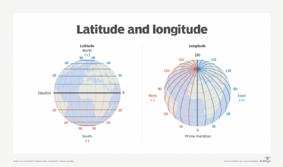
Georeferencing is an essential step in data integration, where GPS data points are aligned with a reference system, such as latitude and longitude. This ensures that the final maps are accurately georeferenced and can be used for various applications, such as navigation or urban planning.
3. Map Generation
Once the GPS data has been cleaned and integrated, it can be used to generate maps. This involves using specialized software or algorithms to interpolate the collected GPS points and create a continuous representation of the mapped area.
The map generation process can include various elements, such as boundary lines, topographic features, or point data. Depending on the specific requirements of the mapping project, different visualization techniques, such as heat maps or contour lines, can be applied to represent the GPS data effectively.
GPS Data Accuracy and Limitations
While GPS technology has provided us with an invaluable tool for mapping and navigation, it is essential to understand its limitations and potential sources of error. Here are some factors that can affect the accuracy of GPS data:
1. Atmospheric Conditions
GPS signals can be affected by atmospheric conditions, such as clouds, heavy rain, or solar activity. These conditions can result in signal delays or interference, leading to less accurate GPS data.
To mitigate these effects, advanced GPS receivers and correction techniques, such as differential GPS, are used to improve accuracy.
2. Signal Interference
GPS signals can be disrupted or distorted by signal interference from nearby structures, buildings, or electronic devices. This interference can lead to position errors or reduced signal strength. In urban areas or densely populated environments, GPS accuracy may be compromised due to signal obstructions.
3. Multipath Reflection
Multipath reflection occurs when GPS signals bounce off surfaces, such as buildings or large objects, before reaching the receiver. This can lead to signal distortion and inaccuracies in GPS positioning. Advanced receivers and signal processing techniques are employed to mitigate the effects of multipath reflection.
Despite these limitations, GPS technology continues to evolve, with advancements in receiver technology, signal processing algorithms, and satellite systems like Galileo and BeiDou.
These advancements bring us closer to achieving highly accurate and reliable GPS data for mapping and navigation purposes.
Future of GPS Data Collection and Processing
The field of GPS data collection and processing is continually evolving, driven by technological advancements and the increasing demand for accurate and up-to-date maps. Here are some emerging trends and technologies that will shape the future of GPS data collection and processing:
1. Cloud-based Data Processing
With the rise of cloud computing, processing large volumes of GPS data has become more feasible and cost-effective.
Cloud-based platforms offer the computational power and scalability required for analyzing and processing massive datasets, enabling faster and more efficient map generation.
2. Machine Learning and AI
Machine learning and artificial intelligence (AI) techniques are being applied to GPS data processing, enabling automated data cleaning, integration, and map generation.
These algorithms can learn from large datasets, improving the accuracy and efficiency of GPS data processing tasks.
3. Improved Satellite Systems
Advancements in satellite systems, such as the deployment of new constellations like SpaceX’s Starlink or OneWeb, promise to enhance the availability and accuracy of GPS signals. These satellite systems aim to provide global coverage and improved positioning accuracy, benefiting GPS data collection and processing for mapping.
In conclusion, GPS data collection and processing for mapping involve various methods and techniques, ranging from real-time kinematic surveying to mobile mapping systems and crowd-sourced data.
The collected data goes through a process of cleaning, integration, and map generation to produce accurate and detailed maps.
While GPS technology has its limitations, ongoing advancements and emerging technologies hold the potential to further improve the accuracy and efficiency of GPS data collection and processing in the future.
Frequently Asked Questions
GPS data collection and processing are crucial for creating accurate maps. Here, we’ll answer important questions about how GPS data is collected and processed for mapping purposes.
1. What devices are used for GPS data collection?
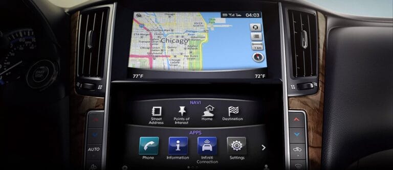
Various devices are used to collect GPS data for mapping, including smartphones, tablets, GPS receivers, and aerial and satellite imagery. These devices use Global Positioning System (GPS) technology to capture location information, such as latitude and longitude coordinates, altitude, and sometimes even information about speed and direction.
While smartphones and tablets have built-in GPS capabilities, standalone GPS receivers offer more precise and specialized data collection for mapping purposes. Aerial and satellite imagery, on the other hand, provide valuable context and visual information that complement GPS data.
2. How does GPS data collection work?
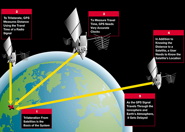
GPS data collection involves a network of satellites orbiting the Earth, which transmit signals to GPS devices on the ground. Each GPS device receives signals from multiple satellites and uses this information to calculate its precise location.
The GPS receiver in the device measures the time it takes for signals to travel from the satellites to the device. By comparing the time differences between these signals and the known location of the satellites, the GPS device can determine its exact position on the Earth’s surface. This information is then recorded for further analysis and mapping.
3. What is the process of GPS data processing for mapping?
Once GPS data is collected, it goes through a process known as GPS data processing. This involves analyzing and interpreting the collected data to create meaningful and accurate maps. The process typically includes several steps, such as data cleaning, data integration, data transformation, and map generation.
Data cleaning involves removing any erroneous or inconsistent data points to ensure the accuracy of the final map. Data integration combines GPS data with other relevant data sources, such as aerial imagery or geographic information systems (GIS), to enrich the map and provide additional context.
Data transformation converts the raw GPS data into a format compatible with mapping software. Finally, map generation uses specialized software to visualize the processed GPS data and create the final map.
4. What are the applications of GPS data in mapping?
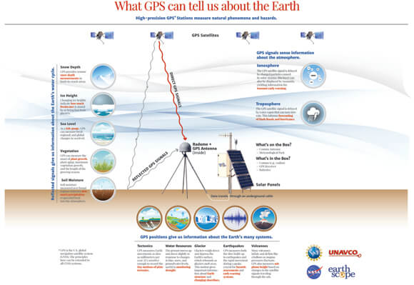
GPS data plays a vital role in a wide range of mapping applications. It helps in creating accurate and up-to-date maps for navigation, urban planning, transportation management, environmental monitoring, and disaster management. GPS data is also used in precision agriculture, surveying, and geological mapping, among other fields that require precise location information.
For example, GPS data enables navigation systems to provide turn-by-turn directions, helping drivers reach their destinations efficiently.
In urban planning, GPS data helps identify transportation patterns and optimize infrastructure development. Environmental monitoring uses GPS data to track wildlife movements and study changes in ecosystems. The applications of GPS data in mapping are diverse and impact various aspects of our daily lives.
5. How is GPS data accuracy ensured for mapping purposes?
Ensuring the accuracy of GPS data is crucial for creating reliable maps. GPS devices and software employ several techniques to improve accuracy.
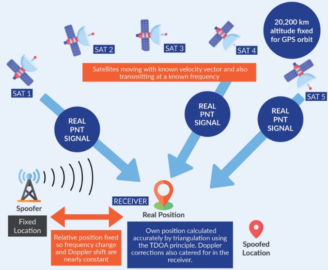
One common technique is Differential GPS (DGPS), which uses a network of fixed reference stations to correct the errors introduced by the GPS signals as they pass through the Earth’s atmosphere.
Additionally, using multiple GPS satellites and sophisticated positioning algorithms helps improve accuracy. Some GPS devices also support Real-Time Kinematic (RTK) technology, which offers even higher accuracy by providing real-time corrections based on data from additional reference stations.
Regular calibration and quality control measures throughout the data collection and processing stages further enhance the accuracy of GPS data for mapping purposes.
Mapping is how we create detailed and accurate representations of the world around us. GPS data is an essential part of this process, helping us collect and process information to make these maps.
GPS satellites in space provide precise signals that GPS devices on the ground use to determine their location. GPS chips in smartphones, tablets, and other devices receive these signals and calculate latitude, longitude, and altitude.
This information is then combined with other data like images and road networks to create detailed and useful maps for navigation and other purposes.
To collect GPS data, mapping companies use specialized vehicles equipped with GPS receivers that track their precise location as they move. These vehicles also have cameras and lasers that capture images and 3D measurements of the surrounding environment.
Once the data is collected, it goes through a process called post-processing, where it is analyzed, cleaned up, and merged with other data sets. This ensures the accuracy of the maps and helps in identifying and correcting any errors.
Ultimately, the goal of collecting and processing GPS data is to create maps that are reliable, up-to-date, and can be used for navigation and various other applications.